Early Exploration Through The Highlands (1800-1853)
Following the Toronto Purchase of 1785, the British initiated a series of treaties to settle a strip of land two townships wide (approximately 30 kilometers) along the north shore of Lake Ontario. The territory above the settlement was referred to as “Indian Land,” where a number of fur-trading posts were located. The two most northern posts operated in the future villages of Fenelon Falls and Bobcaygeon.
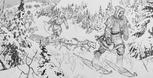
In 1815, a lone fur trapper named Sam Moore paddled north from the Fenelon Falls trading post. After a few days, he had travelled two lakes above Balsam Lake. He stopped by a small waterfall and decided to build a sod-and-log trading post there. After a few years, Sam’s business had become so successful that the traders from Fenelon Falls attacked and forced him to flee upriver.
In 1819, Sam built a stone-and-timber trading post on the east bank of the river that flowed into northern end of what would later be known as Gull Lake. Over the next two decades, Sam enlisted over a dozen of his younger brothers, cousins, and brothers-in-law to join him in forming a fur-trading business. The company, which lasted until 1865, worked a triangular territory from Gull Lake to St. Nora’s Lake to Redstone Lake. The foundations of Sam’s trading post are still visible under the water today, less than two miles from Bob Lake.
Henry Moore, one of Sam’s younger brothers, decided to give up trapping after he was married. In the late 1830’s, he cleared a farm just north of the trading post. This was the beginning of Lutterworth village, a farming and trading community. Today Murdoch Road runs south from Deep Bay Road to the area where the village’s western farms were located. Prior to its amalgamation with Minden Hills, the northern line of Lutterworth township crossed the southern portion of Bob Lake not far from the site of the current dam.
In 1819, the British government began searching for a more direct water route between Georgian Bay and the Ottawa River. It was hoped that this route would eliminate the necessity of travelling many miles south, east through the Great Lakes and north again to Ottawa. Officers of the Royal Engineers crossed and recrossed the areas now known as Muskoka and Haliburton to explore several chains of lakes and rivers that could be accessed from Lake Simcoe.
The first expedition, led by Lieutenant James Catty, travelled along the Talbot River into Balsam Lake. Catty reported, “We left it by the North East end and ascended a fine broad and deep stream for about seven miles into a chain of small narrow lakes which communicate with each other by separate streams. From the second to third Lake, the Navigation is interrupted by four separate falls of about twelve feet each, and after passing the third Lake, we were generally obliged to carry from one to the other as streams which joined them were so filled with trees as to prevent our taking up the canoes.” 1. This deep stream became the future Gull River and the second and third lakes are known today as Moore and Gull Lakes.
After Gull lake, Catty’s route is somewhat vague. It is likely he followed Gull River to the white-water rapids (above Minden), passing Bob Lake along the way, before portaging into the chain of Kashagawigamog Lakes. He could then travel through a series of lakes to the Madawaska River, which joined the Ottawa River.

During the next 10 years, further explorations led by Lieutenants Marlow, Smith, Briscoe, and Walpole followed a number of First Nations’ routes. In the fall of 1827, Walpole’s expedition retraced Catty’s probable journey from Lake Simcoe to the Madawaska River. Walpole learned that squatters had named Moore Lake and Moore’s Falls in honour of Sam and his original trading post. Gull Lake and Gull River were also named.
In 1818, surveying began in the southern part of the United Counties of Peterborough and Victoria. The three main settlements in the area were: Scott’s Plain (Peterborough); Williamstown (Omemee) in 1825; and Purdy’s Mills in 1827. The English, Irish, and Scottish settlers brought their attitudes about drinking with them to these new settlements.
The founding of most villages followed a pattern: first, locate a good water source to power the grist and saw mills (the first businesses to be built); second, open a general store; third, start official distilleries and unofficial back-woods stills; and fourth, open a hotel with an attached tavern. By the late 1840s, Omemee had a population of less than 500 but hosted 22 businesses that made or sold alcohol.
In 1848, a surveyor ran the line that became Bobcaygeon Road through northern Peterborough County. Settlers followed this line and squatted on nearby land. Two years later, when a map of Northern Peterborough County was completed, Bob’s Lake was clearly labelled. This was the earliest reference to the lake’s name that I found.
As settlers continued to move into the Boshkung and Halls Lake districts, they discovered that a number of fields had been cleared and recently cultivated. This was likely done by members of the First Nations during previous summer visits to the area for fishing, hunting and trapping. With the arrival of the settlers, they were unable to return.
The last major expedition through Muskoka and Haliburton was led by Alexander Murray in 1853. His objective was to complete “a geological and topographical survey of the territory lying between Lake Huron and the Ottawa River” for the Geological Survey of Canada. Starting in the spring with five men and a native guide, the expedition left Georgian Bay in three canoes. The travelers passed through Lake Muskoka, Lake of Bays and Algonquin Park to reach the Ottawa River. On the return trip, they headed west along the York River route, paddling through Golden, Round, Kamaniskeg, Baptiste, Grace, Drag, Kashagawigamog, Horseshoe, Gull, Moore, Shadow, and Balsam Lakes before ending at Lake Simcoe in the late fall. Murray reported, “There are also good tracts of land around Kah-shah-gah-wiamog and Gull Lakes; and I was informed by the trapper I met there, that the country east of the latter lake was well adapted for settlement over a large area” 1.
Footnotes
- Muskoka and Haliburton 1615-1875, A Collection of Documents by Florence B. Murray
Have a comment or contribution? Just use the “Leave a Reply” form below or connect with Greg by submitting the contact form on The History and Stories of Bob Lake page. Go back to <<< Chapter 1 or proceed to Chapter 3 >>>
